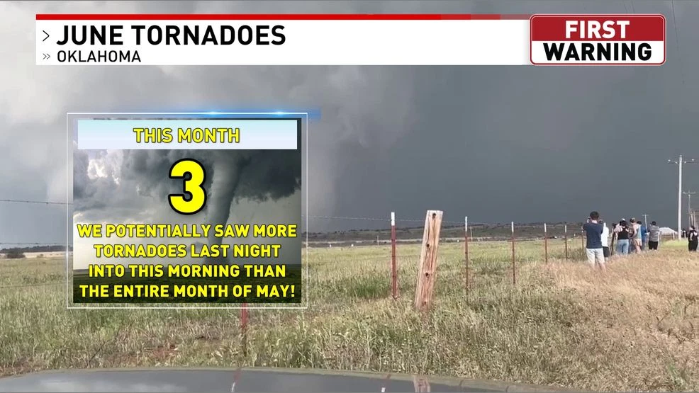
A powerful derecho tore through the state overnight, unleashing strong winds and spawning several tornadoes that caused damage and left tens of thousands without power. The NWS has since confirmed three tornadoes near El Reno, Harrah, and Wetumka. We’ll have more details as the NWS releases additional information.
Public Information Statement
National Weather Service Norman OK
322 PM CDT Mon Jun 22 2026
…NWS Damage Survey for 6/22/2026 Tornado And Damaging Wind Event…
.Overview…A Derecho moved across Oklahoma during the overnight hours on Monday, June 22nd. The Oklahoma Mesonet site at Hinton measured a wind gust of 102 mph at 115 AM CDT. While the majority of the area saw severe thunderstorm winds, we have been able to confirm at least 3 tornadoes from early this morning.
The El Reno tornado assessment will see significant updates following this initial preliminary statement. Surveyors will refine the exact track, rating, and estimated winds over the coming days.
.El Reno…
Rating: EFU / TBD
Estimated Peak Wind: N/A / TBD
Path Length /statute/: TBD
Path Width /maximum/: TBD
Fatalities: 0
Injuries: 0
Start Date: 06/22/2026
Start Time: 01:40 AM CDT
Start Location: 3 NW El Reno / Canadian County / OK
Start Lat/Lon: 35.5528 / -97.9988
End Date: 06/22/2026
End Time: 01:48 AM CDT
End Location: 2 WNW El Reno / Canadian County / OK
End Lat/Lon: 35.5393 / -97.9865
Survey Summary:
As noted, this information remains very preliminary as the survey continues. Several homes sustained damage north of Business I-40 near Reformatory Road, where multiple power lines and poles also came down. The damage path stretches roughly a mile to the northwest before turning south and southeast.
Harrah…
Rating: EF1
Estimated Peak Wind: 90 mph
Path Length /statute/: 4.9 miles
Path Width /maximum/: 0 yards
Fatalities: 0
Injuries: 0
Start Date: 06/22/2026
Start Time: 02:15 AM CDT
Start Location: 2 WNW Harrah / Oklahoma County / OK
Start Lat/Lon: 35.5022 / -97.1939
End Date: 06/22/2026
End Time: 02:21 AM CDT
End Location: 3 E Harrah / Lincoln County / OK
End Lat/Lon: 35.4858 / -97.1114
Survey Summary:
A QLCS tornado likely began just north of NE 23rd Street and the Kickapoo Turnpike. The tornado moved south and east through Harrah, producing tree and power line and power pole damage. The circulation moved across the county line, before dissipating.
.Wetumka…
Rating: EF1
Estimated Peak Wind: 100 mph
Path Length /statute/: 5.3 miles
Path Width /maximum/: 0 yards
Fatalities: 0
Injuries: 0
Start Date: 06/22/2026
Start Time: 03:10 AM CDT
Start Location: 3 W Wetumka / Hughes County / OK
Start Lat/Lon: 35.2294 / -96.3006
End Date: 06/22/2026
End Time: 03:16 AM CDT
End Location: 2 E Wetumka / Hughes County / OK
End Lat/Lon: 35.2377 / -96.2098
Survey Summary:
The Wetumka tornado touched down at 3:10 a.m. south of SH9, west of Wetumka, then pushed eastward, damaging trees and power lines near the intersection of SH9 and SH27. The most intense damage — consistent with EF1 intensity and wind speeds — struck the east side of town, where trees and power poles took significant hits. South of SH9 along N381 road, the tornado also uprooted several trees.
EF Scale: The Enhanced Fujita Scale classifies tornadoes into the following categories:
EF0…..65 to 85 mph
EF1…..86 to 110 mph
EF2…..111 to 135 mph
EF3…..136 to 165 mph
EF4…..166 to 200 mph
EF5…..>200 mph