Chicago braces for another round of severe weather Thursday, with a significant risk of a dangerous tornado outbreak expected to develop through the afternoon and evening hours.
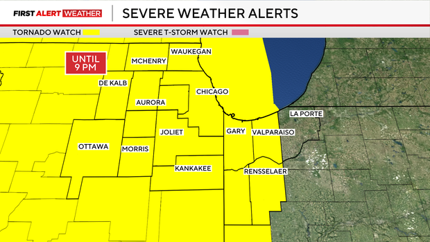
A Tornado Watch remains in effect across the entire Chicago metro area — covering Boone, Cook, DuPage, Grundy, Kane, McHenry, De Kalb, Kankakee, Lake, La Salle, Kendall, Livingston, Lee, Ogle, Will and Winnebago counties in Illinois, along with Benton, Jasper, Newton, Lake and Porter counties in Indiana — through 9 p.m.
A High Wind Warning is in effect for the city of Chicago, the surrounding metro area and Northwest Indiana until 4 p.m., with damaging gusts up to 60 miles per hour possible, the National Weather Service said. The wind is expected to bring down trees and power lines and could pose serious hazards for tall vehicles on roadways.
The Chicago area has been upgraded to a Level 4 out of 5 severe storm risk. The National Weather Service warns that the tornado threat Thursday is notably higher than during a typical severe weather event, with an increased chance of more dangerous and violent tornadoes as well. Residents are urged to stay weather-aware throughout the day and be ready to seek shelter immediately if a tornado warning is issued, given the potential for violent tornadoes.
This marks Chicago’s first Level 4 risk since July 15, 2024, when the area saw a record tornado outbreak with 32 touchdowns. Forecasters note that this level of risk typically occurs only once every two years.
A Flood Watch has also been issued for the entire Chicago area and Lake and Porter counties in Indiana through 11 p.m.
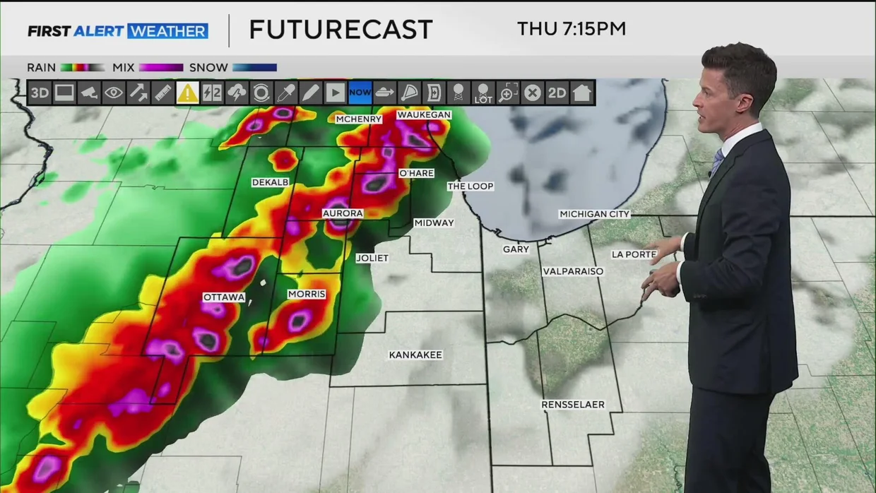
The greatest danger will arrive in the afternoon and evening, primarily between 4 p.m. and 8 p.m., as heat, humidity and powerful upper-level winds combine to fuel conditions favorable for significant severe weather.
These storms carry the potential to produce damaging winds, large hail and violent tornadoes — which the NWS defines as EF-4 and EF-5 strength.
The National Weather Service said a tornado outbreak should be expected, widespread across the area, with the highest risk concentrated in the western suburbs.
How to stay safe during a tornado warning
The NWS issues a tornado watch when conditions are favorable for tornado development, and a tornado warning when a tornado has actually been spotted or indicated by radar.
If a tornado warning is issued for your area, take immediate steps to protect yourself, your family and your pets. When a tornado warning is issued:
- Immediately seek shelter in your basement or the lowest floor of your home or building in an interior room without windows. Put as many walls as possible between yourself and the outside, and stay away from windows at all costs.
- In homes or public buildings without basement access, move to a small interior room — such as a bathroom, closet or interior hallway — on the lowest level available. Close all doors to the hallway for added protection and, if possible, get under something sturdy. The National Weather Service recommends using pillows, blankets and quilts to shield yourself from flying debris, or wear a motorcycle or bicycle helmet if you have one.
- If you live in a mobile home, leave ahead of the approaching weather and take shelter in a sturdy building for the duration of the storm.
- If you are outside, in a vehicle or unable to reach a sturdy building, get into the nearest ditch, low-lying area or underground culvert, lie flat on your stomach and cover your head with your hands. Do not shelter under highway overpasses — tunneling effects can actually intensify wind speeds.
- Stay away from doors, windows and outside walls, and protect your head at all times.
Keep your phone charged ahead of severe weather and put together a small kit with water, flashlights, a radio and any essential medications in case you need to shelter in place for an extended period. Given the high risk of wind damage and power outages Thursday, advance preparation is strongly advised.
Chicago area still cleaning up after Wednesday storms
Thursday’s threat arrives as the Chicago area is still recovering from Wednesday’s storms, which downed trees and power lines and left hundreds of thousands of customers without electricity.
ComEd reported more than 5,600 active outages as of Thursday morning, with nearly 200,000 customers affected. The utility expected to restore 80% of those outages by 11 p.m. Saturday. Customers can monitor updates on the ComEd website.
Large trees toppled across the Chicago area in Wednesday’s storms. Reports also emerged of lightning striking a house in Orland Park and strong winds tearing sections of a roof off a building in Stickney.
Conditions are expected to improve Friday, with sunshine returning and humidity dropping. The pleasant weather is set to continue into the weekend, though an additional chance for thunderstorms arrives late Saturday — with hail and wind as the primary threats if those storms turn severe.