
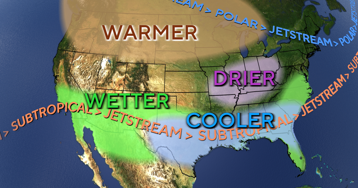
El Niño has grown exceptionally powerful this year, with conditions now officially meeting the threshold of what many are calling a “super El Niño.” The National Oceanic and Atmospheric Administration’s Climate Prediction Center confirmed that the phenomenon, which exerts significant influence on weather and climate across the globe, has intensified considerably and continues to strengthen. The agency further noted that its effects through the following spring could potentially be regarded as historic in scale.
What is El Niño?
El Niño is a climate pattern characterized by the warming of ocean waters within a specific region of the Pacific Ocean near the equator. It occurs every two to seven years and typically persists for a period of nine to twelve months. When El Niño is active, a substantial portion of the world also experiences elevated temperatures. In September, researchers at the University of Chicago projected that approximately 451,000 more people would die worldwide during this year’s El Niño compared to a typical year, largely due to excessive heat exposure. The impacts of El Niño vary considerably across different regions of the world, influencing hurricane frequencies, altering sea levels, and at times triggering widespread flooding, severe drought, and seasonal snowfall amounts that deviate significantly from historical averages. Fishing and agricultural industries frequently bear tangible consequences from these changes, as do utility providers that rely on rainfall and wind to generate power.
A “super” El Niño
Considerable attention has surrounded the term “super” El Niño, which refers to an El Niño climate pattern that is particularly intense and far-reaching in its impact. It is not, however, an officially recognized designation, and neither NOAA nor the World Meteorological Organization formally acknowledges it. Both agencies instead classify this year’s El Niño as “very strong.” NOAA determines that an El Niño event is underway when El Niño conditions are detected in the tropical Pacific for a minimum of three consecutive months, repeated five times in succession. An El Niño event is officially declared when sea surface temperatures in that region rise 0.5 degrees Celsius or more above the historical average. As of November 12, sea surface temperature anomalies exceeded 4 degrees Celsius as El Niño continued to strengthen and its conditions spread further, according to NOAA’s Climate Prediction Center. Should temperatures rise to 2 degrees or more above average across five consecutive three-month periods, the event will be formally classified as a “very strong” El Niño.
El Niño’s impact on North America
As a result of the warmer climate conditions associated with El Niño, the southern portion of North America tends to experience wetter weather, as more frequent storm systems move inland from the Pacific Ocean. The northern portion of the continent, by contrast, is likely to see milder conditions with reduced precipitation throughout the winter months. Within the United States, southern states should prepare for a more turbulent winter than is typical. According to NOAA’s winter outlook, those regions face an elevated likelihood of receiving precipitation in the form of both rain and snow.
El Niño’s impact worldwide
The northern portion of South America and central Africa typically experience drier conditions during the winter months of an El Niño event, while Australia and southern Asia also tend to see reduced rainfall and diminished storm activity. Drought risks are heightened in regions where drier weather is anticipated. Conversely, wetter conditions are expected to develop in certain areas, including eastern Asia and the southern portion of South America, both of which are forecast to receive increased precipitation as a direct result of El Niño. While additional moisture could potentially alleviate existing drought conditions in some of these areas, it also carries a significant risk of severe flooding. El Niño’s contrasting effects across Central and South America have raised serious concerns this year, as a combination of drought and record-breaking precipitation devastated agricultural sectors and prompted multiple countries to declare national emergencies.
How El Niño affects hurricanes
The manner in which El Niño influenced hurricane seasons across both the Atlantic and Pacific oceans this year stands as one of the most evident demonstrations of its reach. In the Atlantic, El Niño tends to generate conditions that suppress the development of tropical storms, while the opposite set of atmospheric conditions promotes their formation in the Pacific. It played a central role in the Atlantic basin’s record-low tropical storm and hurricane activity this year while simultaneously contributing to the Pacific season’s record-breaking intensity. Meteorologists monitor the movement of Saharan dust in the atmosphere off the western coast of Africa to forecast tropical activity in the Atlantic basin. When El Niño conditions are present, the drier atmospheric environment intensifies Saharan dust dispersal, which in turn reduces the potential for tropical storm development.
In the Pacific, the warmer ocean waters produced by El Niño create ideal conditions for storm systems to develop into tropical storms or hurricanes. In the Western Pacific, where tropical cyclones are referred to as typhoons, these systems are more likely to escalate into dangerous “super typhoons” during an El Niño period, at times delivering catastrophic consequences to parts of eastern Asia. Weather agencies have tracked 32 typhoons thus far in 2026. Super Typhoon Sinlaku in April and Super Typhoon Champi in October tied as the most powerful typhoons of the year in the Western Pacific, both achieving Category 5-equivalent strength with sustained winds of up to 185 miles per hour. The Eastern Pacific has recorded 21 named tropical systems this year, with some generating large waves along the West Coast of the United States that eroded coastal areas. In the Central Pacific, Hawaii experienced five named tropical systems that passed in close proximity, bringing heavy rainfall, powerful winds, and flash flooding.
El Niño’s overall strength often determines the degree to which it shapes global weather patterns. This year’s event ranks among the strongest on record, and NOAA has projected that it will most likely persist through March, meaning that months of potential consequences still lie ahead. El Niño events have been growing stronger and longer over time, with scientists connecting the current conditions to this year’s record-breaking heat. Notable recent El Niño events occurred from 2023 to 2024, 2018 to 2019, 2014 to 2016, 2009 to 2010, and 2004 to 2005. In 2015, only 12 named tropical systems were recorded in the Atlantic, while the Eastern Pacific tracked 18 named systems , a pattern broadly comparable to what has been observed this year.