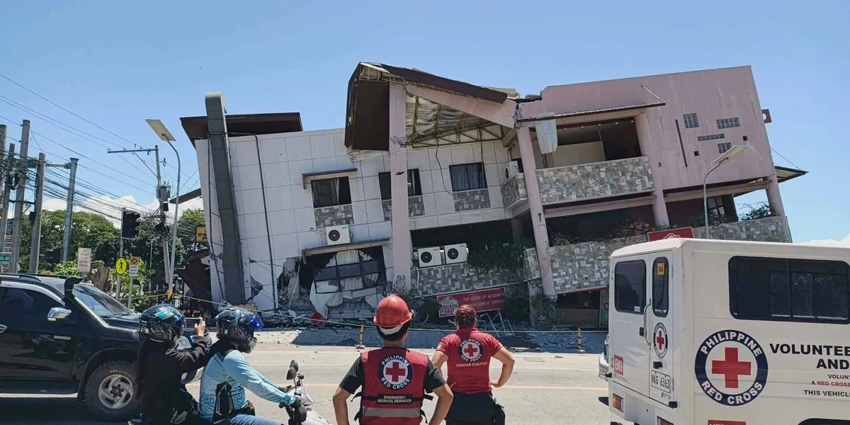
A powerful 7.8-magnitude earthquake struck off the southern Philippines on Monday, leaving at least 35 people dead and more than 200 others injured, most of them trapped in collapsed structures. The disaster also drove a 1-meter (3-foot) tsunami into nearby coastlines.
Multiple mostly low-rise buildings crumbled or suffered severe damage in the hard-hit city of General Santos. Tsunami damage was confirmed in at least one southern coastal village, while smaller waves were recorded as far as Indonesia, Palau, and southern Japan.
The earthquake also set off a landslide in Glan, a municipality in Sarangani province, killing 13 villagers, provincial disaster-mitigation official Rene Punzalan told the DZBB radio network. Four additional villagers also died elsewhere in Sarangani, he said.
The quake was the strongest to strike the Philippines this year, according to Teresito Bacolcol, director of the Philippine Institute of Volcanology and Seismology. He urged residents to seek guidance before re-entering damaged buildings and homes, warning that aftershocks could cause further collapses.
The United States, a treaty ally of the Philippines, said it was coordinating with Manila and stood ready to support the country’s relief efforts. France, Japan, and New Zealand also offered their support.
“Our pickup truck suddenly jerked and I thought we had a flat tire,” Rod Sosmeña, a regional director of the Office of Civil Defense, told The Associated Press from General Santos, where he was traveling when the quake struck at 7:37 a.m.
“The shaking was very strong and people dashed out of houses into the streets,” Sosmeña said.
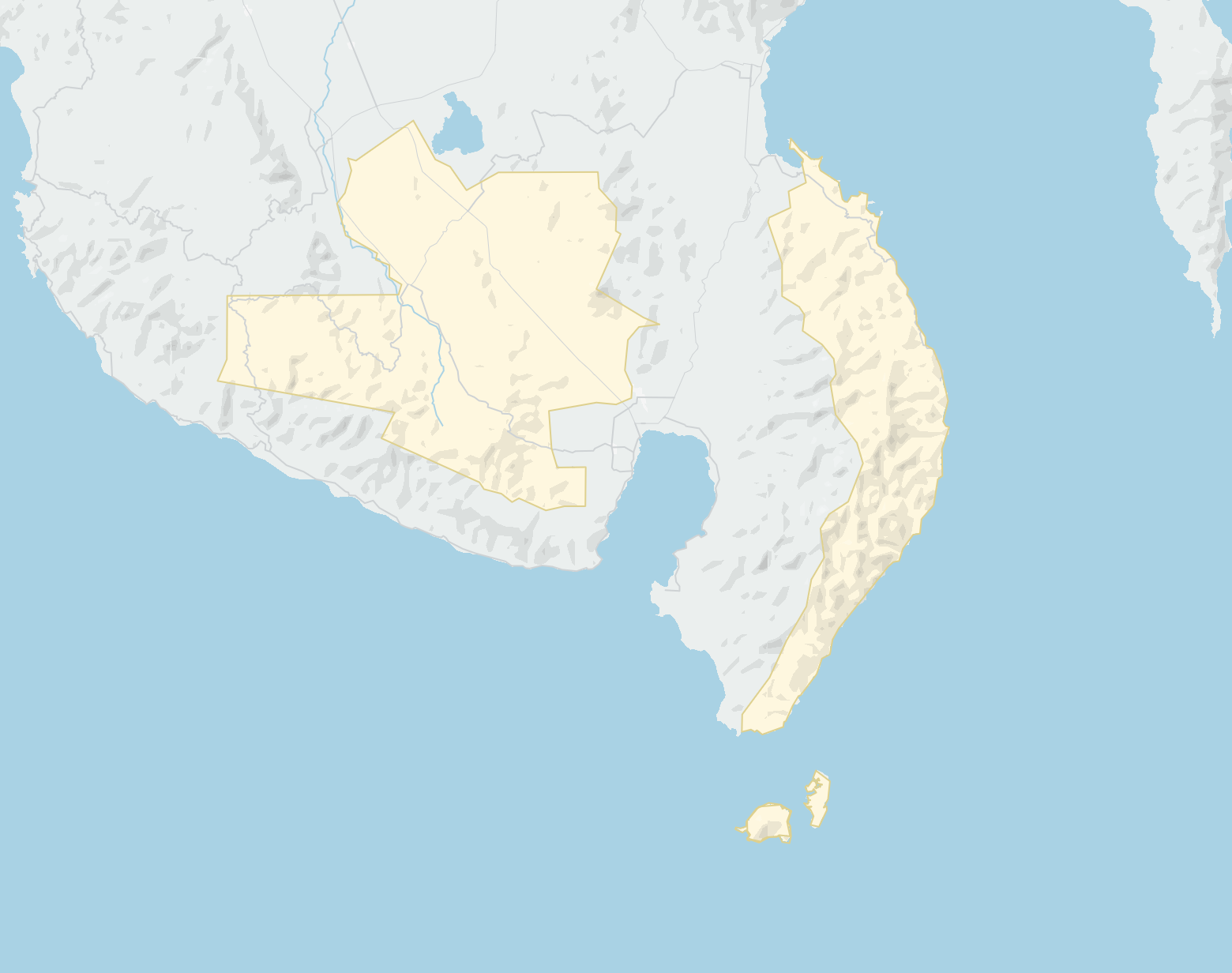
Epicenter in sea off Mindanao
More than 100 uniformed students and a dozen teachers had gathered for a flag-raising ceremony at a coconut tree-lined grade school in the rural town of Malita in Davao Occidental province when the ground began to shake, turning the first day back after a two-month summer break into chaos.
“Their excitement on the first day of school turned to trauma,” school principal Rosavel Cachuela told the AP.
Most of the young students remained seated and still despite some screaming in panic and bursting into tears, which prevented any injuries, Cachuela said. She added that a shed collapsed onto a motorcycle, destroying it.
At least four people remained missing in General Santos, a port city of more than 700,000 residents and a regional hub for the tuna export industry. Search and rescue teams worked to locate survivors who may have been trapped inside a supermarket, a warehouse, a grade school, and other small structures that either collapsed or sustained severe damage, officials said.
The Civil Aviation Authority of the Philippines said the international airport in General Santos was temporarily shut down following the earthquake, resulting in the cancellation of 17 domestic flights.
The quake’s epicenter was located at sea off Mindanao, the second most populous island in the Philippine archipelago. Bacolcol said it struck at a depth of 33 kilometers (20 miles), approximately 32 kilometers (20 miles) southwest of Maasim town in Sarangani province.
Assessing damage and casualties
President Ferdinand Marcos Jr. ordered the cancellation of classes and directed disaster-response agencies to immediately deploy to quake-affected provinces, declaring that “the national government is moving and we will not leave Mindanao behind.”
The Pacific Tsunami Warning Center announced that the tsunami threat had largely passed roughly five hours after the quake struck. Philippine officials also lifted the tsunami warning by mid-afternoon. Six stilt-mounted shanties were damaged in a coastal village in Zamboanga del Sur province as a result of the earthquake and elevated waves, officials said.
Beyond the Sarangani landslide, most other deaths were caused by collapsing structures and falling debris — including inside a damaged mosque — across the southern provinces of South Cotabato and Davao Occidental, and on Balut Island, according to Sosmeña and fellow disaster-mitigation official Ednar Dayanghirang.
Manila’s DZRH radio network reported that a four-story commercial building housing its provincial station partially collapsed, sending staffers rushing to the ground floor — all escaping without injury.
Tsunami waves near 3 feet measured
Waves reaching 1 meter (3 feet) were recorded in the provinces of Sultan Kudarat and Sarangani. A 1.4-meter (4.6-foot) wave struck Kiamba town at one point, Bacolcol said.
The quake was also felt in Malaysia’s Sabah state on Borneo island, just a short boat ride from the southern Philippines. An 83-centimeter (2.7-foot) tsunami was recorded by a gauge off Indonesia’s Sulawesi island, while the PTWC reported 30-centimeter (1-foot) waves in Palau.
Japan’s Meteorological Agency said waves of up to 20 centimeters (7.8 inches) were detected on the remote island of Chichijima and the central Japanese town of Kushimoto.
The Philippines sits on the Pacific “Ring of Fire,” an arc of seismic faults encircling the ocean, making it highly vulnerable to earthquakes and volcanic eruptions. The archipelago also endures roughly 20 typhoons and tropical storms each year, cementing its status as one of the world’s most disaster-prone nations.